
In this article, I will provide a comparison of the most important technical specifications of 3 GNSS sensors from a surveyor’s point of view. I will be comparing products from 3 most reputable surveying equipment producers- Leica, Trimble and Topcon. Read more to find out, which one is the best.
GNSS measurements
GNSS (Global Navigation Satellite System) is a satellite system used for determining users geographic location anywhere in the world. GNSS systems use triangulation principle to locate the users position through calculations involving signals from multiple satellites. Each satellite transmits coded signals at precise intervals that receiver converts and calculates into geographical position. For a reliable determination of user’s positon, the reciver must collect at least four or more satellite signals at the same time.

Ever since the introduction of GNSS systems for commercial use in 1994, our profession benefited greatly from the wide range of services that GNSS systems provide. Its simplicity, direct results and fast measurements made GNSS sensors indispensable piece of surveyor’s arsenal. With ever growing number of satellite system constellations (GPS, GLONASS, Beidu, Galileo, QZSS) and relatively good prices of these instruments, surveyors use GNSS sensors for a lot of different tasks on the filed – from static or kinematic measurements, stake-outs and so on.
Comparing GNSS sensors
A various number of companies produce GNSS sensors in a wide price range, but in this article, I will present currently the best (in my opinion) products on the market. The main aspect of this comparison will be in the technical data and specifications of these instruments compared to each other and also from a financial point of view. I haven’t been able to actually use any of those instruments, so I cannot judge its user friendliness, battery life and first-hand experience. First, I will present each of the instruments individually, and then I will compare their technical information in a table to see how they line-up and which is currently the best.
Leica Viva GS16
Leica presented its latest GNSS sensor named Viva GS16 recently on the Intergeo 2016. The manufacturer claims that it is one of the first smart self-learning GNSS sensors on the market. It uses advanced software programs such as RTKPlus and SmartLink to increase your productivity on the field. It is capable of adapting to changing conditions by selecting the optimal signals to deliver best possible position even when you are in a tough environment. Leica claims that users can now enjoy uninterrupted accurate positioning even when local correction services aren’t available due to different obstructions or cellular coverage issues. This model features a large number of channels for improved sensitivity and it’s said to have a very fast initialization process (only few seconds). Users can operate this GNSS antenna with SC20 controller or CS35 tablet.

Trimble R8
Trimble’s new R8 GNSS sensor comes integrated with so called 360-techology for supporting all current and future GNSS constellations, which should boost its tracking performance in various problematic locations such as near the woods or in dense urban areas. It also features 2 new Maxwell6 chips and offers (like Leica) and huge amount of channels for satellite signal detection. You can use it with Trimble TSC3 controller or Trimble CU tablet. It also features real-time data sharing platform Trimble Access Service, which allows you to transfer your filed data straight to the office.

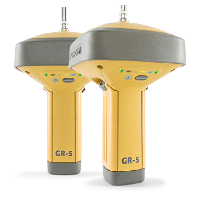
Topcon GR-5
Topcon’s flagship GNSS sensor GR-5 features multi-constellation channel Vanguard GNSS chip and all new Universal Tracking Channel Technology, which uses flexible and dynamic tracking methods to automatically select and track any available satellite signal. Similar to its rivals, GR-5 is programmed to also cope with upcoming systems (Galileo etc.). GR-5 also features patented Fence Antenna design, which supposedly brings superior signal reception and advanced multipath rejection in difficult environments. This GNSS sensor is compatible with Trimble TSC3 controller or Topcon Tesla tablet.
Technical data comparisson
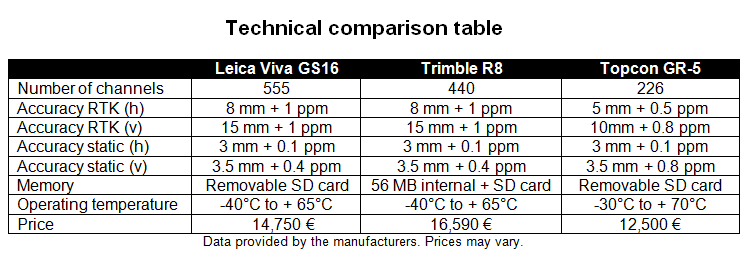
If we take a closer look at a technical comparison table, we can see some interesting points. In the number of channels category the winner is Leica Viva GS16 with 555, and Topcon GR-5 coming last with only 226. But (as manufacturer’s data suggests) Topcon GR-5 stands out in the accuracy category in RTK measurements, beating the competition with 5 mm + 0.5 ppm (horizontal) and 10 mm + 0.8 ppm (vertical) accuracy in ideal conditions. Leica Viva GS16 and Trimble R8 have identical technical specification, apart from the memory storage and number of channels. Interestingly enough, all 3 products achieve almost the same accuracy values in static measurements, with only a little difference in Topcon’s static accuracy (vertical) with 0.8 ppm. Trimble R8 turns out to be the most expensive instrument of the 3, again with Topcon in the first place more than 2000 € cheaper than Leica. So, on paper, the best current GNSS sensor for advanced surveying purposes is … Topcon GR-5!
Sources: http://leica-geosystems.com/products/gnss-systems/smart-antennas/leica-viva-gs16, https://www.topconpositioning.com/gnss/integrated-gnss-receivers/gr-5, http://www.trimble.com/Survey/trimbler8gnss.aspx?tab=Receiver_Comparison_Chart, http://searchnetworking.techtarget.com/definition/GNSS


![Screenshot_2016-08-21-12-02-45[1]](https://surveyingnews.files.wordpress.com/2016/08/screenshot_2016-08-21-12-02-451.png?w=596&resize=596%2C596&h=596#038;h=596&crop=1 "Screenshot_2016-08-21-12-02-45[1]")


You must be logged in to post a comment.